
Incorporating soil data can improve air quality predictions, solutions
Writer: Kay Ledbetter, 806-677-5608, skledbetter@ag.tamu.edu
Contact: Dr. Cristine Morgan, 979-845-3603, clsmorgan@tamu.edu
COLLEGE STATION – Solutions to challenges and policy questions that arise due to drought and increased air quality concerns might well be found by looking down – to the soil.
Dr. Cristine Morgan, Texas A&M University department of soil and crop sciences professor, is working on a Texas A&M AgriLife Research project looking at “What can soil science contribute?” to issues affecting life and human health issues.
“While we know soil water storage capacity and conductivity have a strong influence on energy fluxes, the disconnect is clear between knowledge of soil variability in the soil science community and land surface modeling activities in the atmospheric science community,” Morgan said.
She said through the use of land surface models, scientists can simulate the mass and energy fluxes between the land surface and atmosphere, providing a critical link between hydrological and atmospheric models used to predict air quality.
Hydrological and atmospheric models are used to understand implications of policy changes on the global challenges of food, water and energy security, as well as human health and biodiversity, Morgan explained.
Previous research has shown the importance of soil moisture initialization on the performance of land surface, meteorological and air quality models; yet the progress of incorporating improved soil information that improves soil moisture simulation has been stagnant, she said.
The problem, Morgan said, is the base land surface models, such as the popular Noah-MP or Multiparameterization Land Surface Model, were using outdated soil information.
Collaboration among Texas A&M, Texas Commission on Environmental Quality and the National Center for Atmospheric Research has changed that by making improvements to the limitations of soil representation in the Noah-MP model, she said.
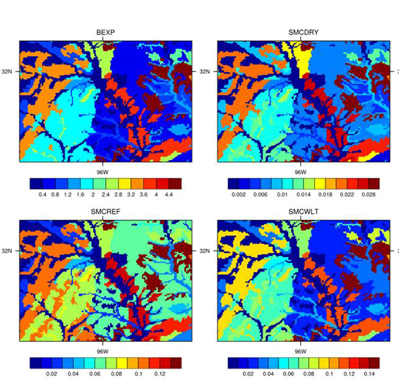
“We wanted to put better information into these models,” Morgan said. “These land surface models were still using soil parameter values clustered by soil textural class in a reference table to characterize soil hydraulic properties,” she said. “They assumed vertically homogeneous soil that is uniformly deep to about 6 feet and used soil maps from the early 1990s.”
Morgan said they found 118 of the 190 soil parameters were different from that of soils in Texas in the current Noah-MP land surface model, which provides soil texture classes and a table of soil properties across the U.S.
Part of the problem, she said, was updates in the U.S. Department of Agriculture Natural Resource Conservation Service database weren’t being used in the Noah-MP model.
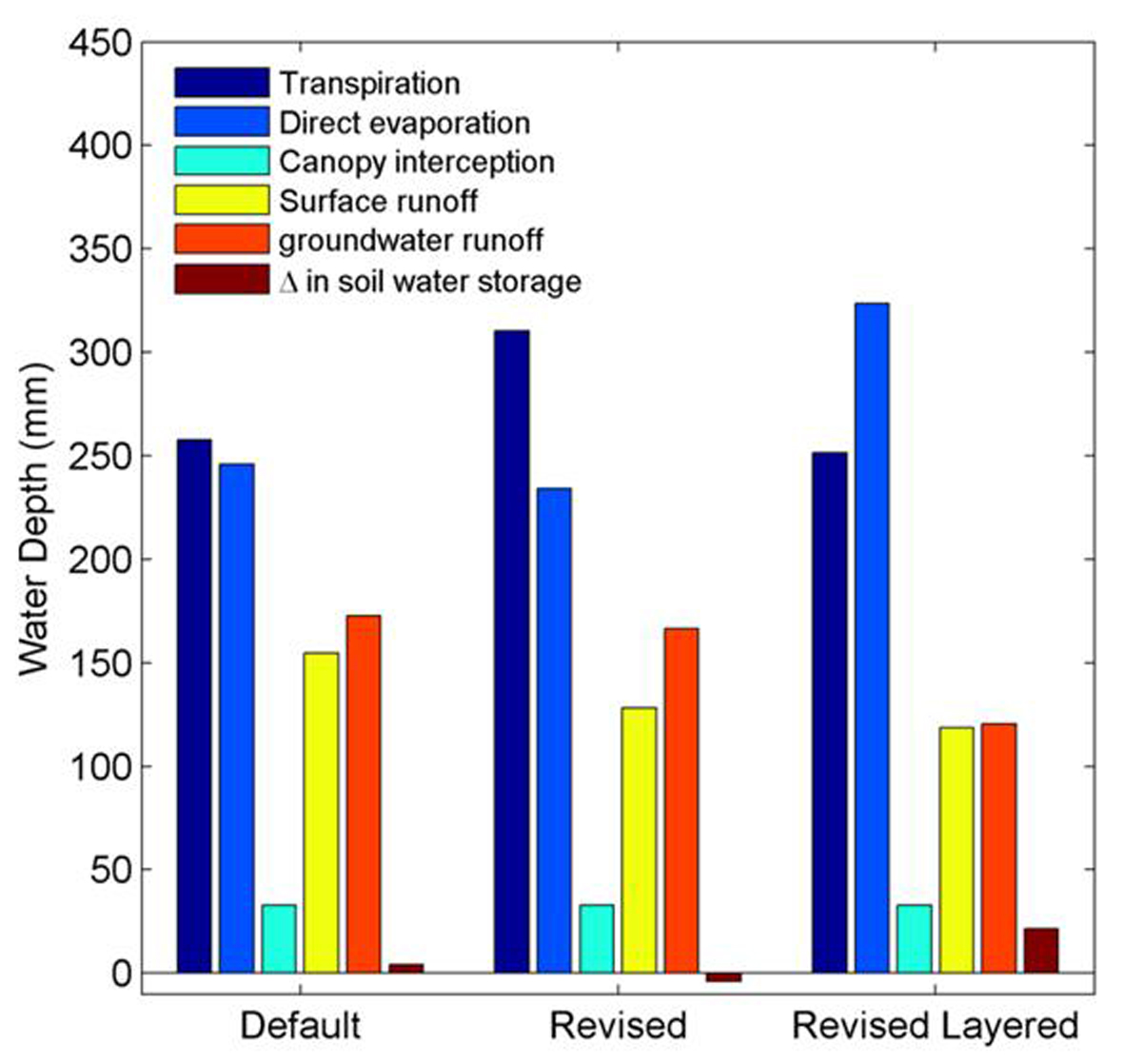
Morgan said they were able to show the effects of improving the look-up table that translates soil texture into soil physical properties and the effects of improving the three-dimensional spatial representation of soil variability. Improving spatial representation of and values of soil physical properties changes how the model simulates the water balance and surface energy fluxes.
“We knew we could improve the information available, so we started in East Texas,”
Morgan said. “The study clearly determined soils are not consistent in depth, which makes a huge difference.”
East Texas is full of soil with a sandy surface and clayey subsurface, causing a large degree in variation in soil properties with depth, she said. Particularly, plant-available water held by clay soils is much higher than that of sandy soils, affecting water availability for transpiration and direct evaporation.
Morgan said their study demonstrated how incorporating current knowledge of soil capability changes across the landscape and at various depths results in significant differences in model output.
By including knowledge of soil heterogeneity, simulated components of the water budget and energy partitioning change significantly, she said.
“Soil provides a significant source of memory in the atmospheric prediction system, so not having proper linkages and storages has the potential for significantly limiting model prediction accuracy.”
Ultimately, she said, a better accounting of soil capability in the soil-plant-water-atmosphere exchanges of energy and mass is vital to soil security and addressing global challenges.


