New report shows changes in Texas borderlands over time
Addresses trends in population growth, land ownership, fragmentation

SAN ANTONIO – Changes in population density, rapid urbanization and rising land values have altered much of the historically rural landscape of the Texas borderlands, according to a recent Texas Land Trends report.
The report, “Trends in Land Ownership Along Texas Borderlands,” was produced by the Texas A&M Natural Resources Institute, or NRI, in collaboration with the Borderlands Research Institute, or BRI, at Sul Ross State University.
It evaluates changes in population density and examines how land ownership patterns and use have changed over the last few centuries within Texas borderland counties due to these drivers of change. It also identifies regions where more rapid transformations have occurred and where similar changes may be expected to occur in the future.
The full report can be found in Resources on the Texas Land Trends website: http://txlandtrends.org/.
County population totals for the report’s 1900 estimates were obtained through the Texas State Historical Association, and 2018 estimates were obtained from the Texas Demographic Center. The report also employed data from the Original Texas Land Survey, a geographic collection of Spanish and Mexican land grants from the 1700s and 1800s.
“Much of what’s special about the Texas-Mexico border relates to the unique historical aspects of the area,” said Dr. Angelica Lopez, an NRI research scientist in San Antonio and the report’s lead researcher. “The borderlands are also home to many interesting flora and fauna, including several endangered and endemic species, as well as to migrating wildlife that travel along its historic corridors.”
Spread out over more than 1,200 miles, the Texas borderlands have the two heavily populated “borderplexes” of El Paso-Juárez and Brownsville-Matamoros at either end. In between are a mixture of rural working lands, growing urban centers, and public park and wildlife refuge lands.

“Over the years, as urbanization throughout the borderlands expanded, it overtook rural lands, leading to their fragmentation and conversion to non-agricultural use,” Lopez explained. “Historically, El Paso and Webb counties were the largest population centers with the old colonial town settlements of El Paso and Laredo, respectively.
“Today, Hidalgo County, which has seen the largest population increase in the McAllen-Edinburg-Mission metropolitan area, closely trails El Paso as the most populated borderland county, followed by Cameron and Webb counties.”
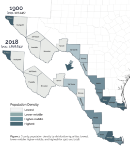
The report shows between 1900 and 2018 the Trans-Pecos counties of Hudspeth, Jeff Davis, Presidio, Brewster and Terrell had low population growth, while the Middle Valley counties of Val Verde, Kinney, Maverick, Webb and Zapata had moderate growth. And the Lower Valley counties of Starr, Hidalgo and Cameron saw the highest growth during that period.
The report also shows how the borderlands, in keeping with the rest of the state, have lost many of their working lands.

“Over the past two decades, we’ve calculated a 13% decrease in total working land acres among Texas borderland counties, as well as a 36% decrease in the size of the typical working land operation such as a farm or ranch,” Lopez said. “This is due to a number of factors, including population growth, increasing land values and an aging landowner base combined with property heirs who may not wish to perpetuate the operation.”
According to the report, from 1997 to 2017 some of the most significant reduction in working lands use among Texas borderlands occurred in Brewster, Cameron, El Paso, Kinney, Maverick, Starr, Val Verde and Webb counties.
“Texas Land Trends data supports the conclusion that farms and ranches are less profitable as they become smaller,” Lopez said. “As working land profitability decreases, the risk of these operations converting to non-agricultural use increases, thereby losing those valuable ‘ecosystem services’ and other benefits derived from healthy private lands.”
She identified some of these ecosystem services and benefits as food and fiber production, clean water, providing wildlife habitat and promoting ecological diversity.
Lopez also noted the report shows a correlation between borderland county population density and land parcel fragmentation.
“As population density increases, so do the number of land parcels, which is an indication of land fragmentation,” she explained. “Over the years, where urban centers along the Rio Grande increased in population density, land parcel fragmentation followed adding to the subsequent increase in overall number of parcels.”
Lopez said approximately 96% of borderlands are currently under private ownership, with some landowners owning multiple parcels.
“Our data shows there are more than 712,000 private landowners within the Texas borderland counties with 22,500 of them owning property within a half-mile of the Rio Grande and 60,190 owning land within 1 mile of the river,” she said.
The report also shows from 1900 to 2018, the total number of land parcels grew from 30,533 to more than a million.
“There are now almost 5,000 parcels along the Rio Grande, more than 31,000 parcels within a half-mile of the river and more than 80,000 parcels within 1 mile of it,” she said.

Based on the data, she said, these changes will continue – and continue to affect land fragmentation and conversion, negatively impacting the benefits provided by private working lands.
“While some may view the borderland as much of the same, its rural and urban counties are very different,” she explained.
Lopez offered the example of the slightly more than 750 people disbursed over rural Terrell County as compared to the more than 860,000 people who reside in sprawling urban Hidalgo County.
“The needs of the residents of rural Terrell County, which has a lower population but larger land parcels of varied shapes, are different than those of the residents of urban and highly populated Hidalgo County, which has smaller, more uniform parcels.”
Lopez said in the coming years many borderland counties will be facing very different challenges related to infrastructure, energy, natural resources and other necessities.
“Knowing more about the trends relating to their population growth, land ownership and use, and differences in their rural and urban areas, is useful in understanding the borderlands as well as planning for their future,” she said.
Writer: Paul Schattenberg, 210-859-5752, [email protected]
Contact: Dr. Roel Lopez, 210-277-0292, [email protected]


