
A new way to map with conservation data
Solving Texas’ natural resources challenges with TxMAP
The Texas A&M Natural Resources Institute, a unit of Texas A&M AgriLife, is seeking to engage land managers, citizens and policymakers in visualizing natural resource conflicts and solutions through a new mapping application called TxMAP.
Like a trusty map from the glovebox with a pocket compass folded in the crease, geospatial data reveals the best routes to take and the dead ends to avoid when navigating natural resources, but ultimately requires inquisition by the user.
The Natural Resources Institute built this new tool utilizing changes and trends that have been explored and developed with Texas data on privately owned farms, ranches and forests in the last few decades.
The public accessibility of the data is a cornerstone of the Natural Resources Institute’s land trends research program, especially where collaboration with conservation-minded groups leads to better advocacy and resources for land stewards. As the adage goes, we shape our tools, and our tools shape us. In this case, they shape the users to be more inquisitive conservationists.
New mapping tool
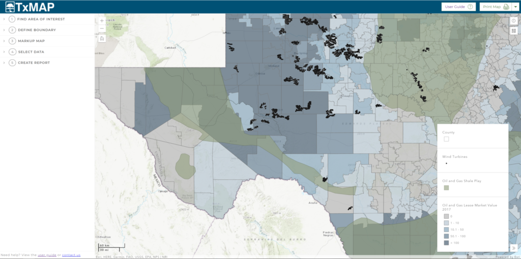
Over the last year, the institute’s geospatial analysis team ideated and developed TxMAP to allow users to see how the institute’s water, wildlife, military and demography data relates to the land around it.
“For example, through TxMAP, we can compare threatened and endangered species data in one region with what’s currently being managed in another,” said Brittany Wegner, Natural Resources Institute project specialist. “Or we can overlap energy production information with military training activity to ensure development will not hinder military preparedness or conservation practices. We can even use mapping to see how human populations relate to variables like river basin management.”

Readers can explore the data layers to answer questions and better visualize natural resources across Texas through boundaries and markups, and then publish and print a summary of their findings.
Individualized map reports created in TxMAP can be used for policymakers, conservation organizations, state and federal agencies as well as private landowners and managers to review desired geospatial information comprehensively.
TxMAP, along with a user guide, is designed to help be the solution for:
— Conservation organizations and land trusts to identify critical habitats, target areas for conservation easements in relation to development and leverage land valuation estimates.
— Legislative staff to direct constituents looking for ways to learn how and where wildlife conservation and threatened and endangered species and water-related projects occur.
— City planners and developers to discover where military training routes occur in relation to areas of interest as a part of standard practice.
— Natural resource professionals, state and federal agencies and educators to understand how resources are set up for those who own land.
— Private landowners and managers, to serve as the mapping component of How to Find Natural Resource Professionals in Texas. With resources visualized, landowners become oriented with their property and can learn how each entity works with the adjacent areas, answering questions that will catalyze their management plans and ability to identify programs that ultimately support the property.
Regardless of how the tool is used, TxMAP was created to continue to increase the public knowledge of trends occurring across the landscape, aiming to better inform and shape the future of our state’s most valuable resource — land.
The original version of this story by Brittany Wegner appeared as a blog in the Texas A&M Natural Resources Institute journal.


