New web tool will facilitate military, wind energy industry collaboration
Tool developed by Texas A&M Natural Resources Institute, others to ensure compatible development of wind energy
A new web tool, Texas Early Notification Tool, TENT, has been designed for energy industry developers to screen for potential project sites and identify potential issues that should be evaluated by the military.
Given recent growth of the wind energy industry in Texas, along with the prevalence of military installations with aviation missions in the state, land-use compatibility is a common concern for both groups. Early engagement between military and industry stakeholders offers a proactive solution to ensuring compatible development.

TENT was developed by the Texas A&M Natural Resources Institute, NRI, a member of Texas A&M AgriLife, in collaboration with the Texas Military Preparedness Commission, TMPC, within the Office of the Governor and Department of Defense Office of Economic Adjustment, DOD-OEA, with input from the American Wind Energy Association, AWEA.
“This project is exciting for many reasons; above all, we were able to find a mutually beneficial balance for all parties involved by facilitating a new conversation between the wind industry and military to advance energy development while protecting the military mission,” said NRI director Roel Lopez, Ph.D.
Lopez said the NRI works in collaboration with Texas A&M AgriLife Research and Texas A&M AgriLife Extension Service on its Military Land Sustainability Program, which has the objective of supporting the military’s mission through integrated land management and collaborative regional planning.
“These efforts support the twin imperatives of military readiness and land stewardship,” Lopez said.
TENT was funded by OEA with matching funds from TMPC. Its main purpose is to facilitate early stakeholder communication between the wind energy industry and military installations and surrounding communities in order to avoid any development that may impede military training and readiness missions, specifically those related to aviation.
To access the tool, go to https://tent.nri.tamu.edu/, where there is also a user guide to explain how to use TENT and export data and reports for offline use.
Texas has 15 active military installations accounting for approximately 1.5 million acres across the state. Each installation has sizable impacts on our nation’s military readiness, the state’s workforce, and the economy, generating at least $101.6 billion in economic activity each year. The wind industry is also a vital component to the Texas economy, ranking first in the nation for existing wind production and investing over $46 billion across the state through 2018.
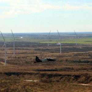
Wind turbines are built outside military fence lines but can still pose potential adverse impacts to low-level airspace, radars, and other aviation systems used in flight training missions if not sited in coordination with the military, Lopez said. Early engagement between military and industry stakeholders offers a proactive solution to ensuring compatible development.

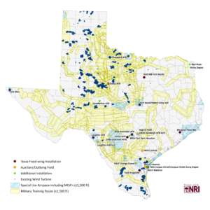
“NRI’s technical expert, retired Navy Captain Tony Parisi, led the effort to update and expand on the institute’s 2010 Wind Energy and Military Airspace in Texas report, which described the status of wind energy development in the state and its proximity to military aviation facilities,” Lopez said. “The updated report captures current wind energy development in Texas and describes early notification areas based on radar line-of-sight or proposed location within particular low-level airspace or within certain proximity to military installations.”
To complement the report, the NRI developed TENT. The publicly available web tool enables industry and other stakeholders to assess potential project locations in the context of military mission compatibility and provide users with military points of contact to facilitate discussion.
“TENT is not for the designation of exclusion areas, but rather for preliminary evaluations and early outreach,” Lopez said. “It is to help mitigate impacts through collaboration between the developers and DoD or to help determine if there are no viable mitigations. It does not replace the need for project-specific evaluations by DoD’s Military Aviation and Installation Assurance Siting Clearinghouse and the Federal Aviation Administration.”
“Wind farm developers have a long history of successfully working with the military to ensure compatibility with military training and operations,” said Tom Vinson, vice president of policy and regulatory affairs, American Wind Energy Association. “Deployment of tools like this that help facilitate continued coordination should only improve the win-wins that result for national security and economic security.”
The report and web tool were made available in a beta version to targeted stakeholders for testing late last summer and received positive feedback. It is now being rolled out publicly.
The web tool allows users to create custom queries based on their area of interest. If the area selected intersects a military asset notification area, the user has the option to generate a printable report that includes an area map and point of contact information for the appropriate military personnel associated with that asset. The web tool also allows users to download data used in the tool, such as locations of wind turbines, installations, radars and notification areas.
“Consistent with the Texas Military Preparedness Commission’s goals to preserve, protect, expand and attract new military missions, assets and installations, this report and web tool will help protect critical military airspace while allowing for future wind energy development through better communications,” said Keith Graf, executive director, Texas Military Preparedness Commission.
“It is important we work with landowners and other stakeholders to maintain working lands, undertake conservation practices that benefit wildlife habitat and promote or continue land-use practices that are compatible with the military’s mission,” Lopez said. “We’re glad to provide our management expertise in programs and policy development where national defense requirements and natural resource interests meet.”
He said toward supporting those efforts, the NRI will continue to maintain and update TENT in perpetuity.
“Future studies that examine other areas of land-use compatibility are already in discussion, and NRI hopes to expand upon the TENT tool.”


